Thursday, May 16, 2024

Maternal Conceptions in Classical Literature and Philosophy

Edited by Alison Sharrock and Alison Keith 
Maternal Conceptions in Classical Literature and Philosophy

Unlike many studies of the family in the ancient world, this volume presents readings of mothers in classical literature, including philosophical and epigraphic writing as well as poetic texts. Rather than relying on a male viewpoint, the essays offer a female perspective on the lifecycle of motherhood. 

Although almost all ancient authors are men, this book nevertheless aims to carefully unpack the role of the mother – not as projected by the son or other male relations, but from a woman’s own experiences – in order to better understand how they perceived themselves and their families. Because the primary interest is in the mothers themselves, rather than the authors of the texts in which they appear, the work is organized according to the lifecycle of motherhood instead of the traditional structure of the chronology of male authors. The chronology of the male authors ranges from classical Greece to late antiquity, while the motherly lifecycle ranges from pre-conception to the commemoration of offspring who have died before their mothers.

The Workmen’s Graffiti in the Valley of the Kings: The Impact of Landscape and Social Networks on Graffiti-making, with a Focus on the Unpublished Graffiti Discovered by Howard Carter in 1915–1918

 Ragab, Muhammad R. 

Graffiti have the power to transform a space within a given landscape into a meaningful place. This study undertakes an in-depth analysis of more than 4000 graffiti created by the workmen of Deir el-Medina in the Theban Mountain during the New Kingdom (c. 1550–1050 BCE), with a particular emphasis on the Valley of the Kings. Additionally, the research contributes to the existing documentation by publishing graffiti numbers 1406–1526, identified as ‘Carter Graffiti’ in the Valley of the Kings. Significantly, these graffiti have not been previously published, addressing a notable gap in scholarly knowledge.Acknowledging that the documentation of unpublished graffiti surveyed by Howard Carter from 1915 to 1918 served primarily an exploratory and documentary purpose, this study seizes the opportunity for extensive, on-site examination and analysis. The principal objective is to elucidate the evolution of graffiti-making practices and the multifaceted roles of these informal inscriptions, particularly within the Deir el-Medina community context. To achieve this aim, the research employs three case studies, undertaking the following endeavours:to employ spatial analysis related theories, including post-phenomenology, to understand the influence of the landscape on the making of graffiti. This includes investigating the spatial and environmental factors that influenced the selection of locations of graffiti and patterns of their making;to apply place-making and place-marking related theories to understand how graffiti transformed spaces into meaningful places;to employ the social network analysis theory as a lens to understand the influence of social relations among graffiti writers on the graffiti-making process. This approach aims to unravel the intricate dynamics and impact of social networks on the making of graffiti within the historical and spatial context of the Valley of the Kings;to examine and analyse the content and context of the graffiti created by the Deir el-Medina community within the Valley of the Kings. This investigation considers the diachronic (historical evolution over time), diatopic (spatial distribution), and socio-stratigraphic (social layers) dimensions. This includes the examination of the characteristics of particular graffiti, such as self-presentation, updated self-presentations in graffiti, and their role in social dynamics and the appropriation of the landscape. The analysis of content also involves investigation of patterns and motivations behind selecting specific locations and the potential influence of earlier graffiti on later creations.This study contributes to a deeper understanding of how the ancient Egyptians employed graffiti as a medium for engaging in discourse not only with their immediate surroundings and landscape but also with their contemporaries and, possibly, posterity. It endeavours to illuminate the diverse functions and significances of graffiti in the lives of the Deir el-Medina community members and beyond.

Place, publisher, year, edition, pages
Uppsala: Acta Universitatis Upsaliensis, 2024. , p. 432
Series
Uppsala Studies in Egyptology, ISSN 1650-9838 ; 7
Keywords [en]
Graffiti, Valley of the Kings, Deir el-Medina, workmen’s community, landscape analysis, Place marking, Socio-spatial dynamics, social network analysis
National Category
Archaeology
Research subject
Egyptology
Identifiers
URN: urn:nbn:se:uu:diva-525118ISBN: 978-91-513-2082-3 (print)OAI: oai:DiVA.org:uu-525118DiVA, id: diva2:1846643
Public defence
2024-05-15, Universitetshuset, sal IX, Uppsala, 14:00 (English)
Opponent
Supervisors
Available from: 2024-04-23 Created: 2024-03-24 Last updated: 2024-04-23
 

Europos: The Archaeology of the Heir of Karkemish during the Classical and Late Antique Periods

di Silvia Di Cristina, Valentina Gallerani 
Europos - Bologna University Press

 The Middle Euphrates Valley has always been a key trade route and cultural melting pot since antiquity. Located on, actually bisected by, the modern border between Turkey and Syria, the site of the ancient Hittite capital city of Karkemish has been the object of archaeological excavations since the late 19th century. In 1911-1914 and 1920, an archaeological expedition by the British Museum uncovered levels of the Bronze and Iron ages, but also gave notice for the existence of a Classical settlement which overlay them, identified with Classical Europos. Their final reports gave only tantalizing bits of material culture dated to the later phases of occupation, especially to the Hellenistic, Roman and Islamic periods. Precisely after one century, in 2011 a Turco-Italian archaeological expedition started the excavations anew on the field, providing much new and firmer evidence on the Classical city as well and implementing an in-depth archival research on unpublished records kept in London. The main aim of this volume consists in giving a general and complete presentation of the data collected by both the British Museum expedition and by the joint project of the Universities of Bologna, Istanbul and Gaziantep, in order to produce a general overview as much complete as possible on Europos after the Seleucid re-foundation of the town, from its beginning in the 3rd century BC till the Late Antique period in AD 5th-6th centuries.

Formato
210 × 297 mm
Pagine
536
Anno
2024
Confezione
Brossura
Lingua
Inglese
ISBN
9791254774267
ISBN online
9791254774274


THE BORDERSCAPE PROJECT

The Borderscape Project is a multidisciplinary endeavor that investigates how the rise of the Egyptian state at the end of the 4th millennium BCE impacted and transformed the socio-spatial landscape of the First Nile Cataract region. The process of state formation instigated profound changes in the socio-economic structure of ancient Egypt, the earliest territorial polity in human history, particularly at the newly established southern border.

Instead of reifying the unification of the Pharaonic state as a dividing event between periods “before” and “after”, The Borderscape Project seeks to evaluate this process along a historical continuum aided by a wide variety of archaeological and geospatial data. The project has three goals: first, it seeks to reconstruct the ancient settlement landscape and understand patterns of growth, development, and abandonment; second, it seeks to understand how the natural landscape was used for economic, religious, and ritualistic purposes through reconstructing ancient patterns of land use, identifying connections and pathways between sites, and detecting moments of change or discontinuity; finally, the project will investigate the social landscape of the region, using archaeological data to identify how group identity or ethnicity was displayed both in Elephantine and the hinterlands of the First Cataract region. The Borderscape Project will evaluate how the Dynastic state dealt with the fluid identities and mobility of the populations in its borderlands compared to the earlier predynastic Period, and develop a new theoretical model for how this earliest example of a borderscape was shaped by rising centralized power. In the coming years, The Borderscape Project aims to produce a monograph and multiple peer-reviewed articles for a scholastic audience, and an interactive WebGIS module to showcase its findings to the general public.

The Borderscape Project is led by Primary Investigator Dr. Maria Gatto, and assisted by postdoctoral researcher and digital specialist Dr. Oren Siegel. The project is based at the Institute of Mediterranean and Oriental Culture of the Polish Academy of Sciences in Warsaw (http://iksiopan.pl/index.php/en/), and our work is funded by the Norway Grants Financial Mechanism 2014-2021 (https://eeagrants.org/) through the Polish National Science Centre (https://www.ncn.gov.pl/?language=en)-POLS Call (2020/37/K/HS3/04097).

The Borderscape Project relies on the research, survey, and excavation data furnished by the Aswan-Kom Ombo Archaeological Project (co-directed by Maria Gatto and Antonio Curci). We are proud to collaborate with many of the wonderful researchers affiliated with this project.


Wednesday, May 15, 2024

Between Jews and Heretics: Refiguring Justin Martyr’s Dialogue with Trypho

 Between Jews and Heretics
Refiguring Justin Martyr’s Dialogue with Trypho
Edition 1st Edition
First Published 2018
eBook Published 16 May 2018
Pub. Location London
Imprint Routledge
Pages 182
eBook ISBN 9781351243490


Justin Martyr’s Dialogue with Trypho is the oldest preserved literary dialogue between a Jew and a Christian and a key text for understanding the development of early Judaism and Christianity. In Between Jews and Heretics, Matthijs den Dulk argues that whereas scholarship has routinely cast this important text in terms of "Christianity vs. Judaism," its rhetorical aims and discursive strategies are considerably more complex, because Justin is advocating his particular form of Christianity in constant negotiation with rival forms of Christianity. The striking new interpretation proposed in this study explains many of the Dialogue’s puzzling features and sheds new light on key passages. Because the Dialogue is a critical document for the early history of Jews and Christians, this book contributes to a range of important questions, including the emergence of the notion of heresy and the "parting of the ways" between Jews and Christians.

chapter |12 pages

Introduction

chapter 1|25 pages

Justin Martyr, Heresy Hunter

Size: 0.38 MB

Size: 0.33 MB

Size: 0.34 MB

chapter 5|44 pages

In Favor of Heresiology

chapter |6 pages

Conclusion


Foundations for a Humanitarian Economy: Re-thinking Boethius’ Consolation of Philosophy

Foundations for a Humanitarian Economy

Creative Commons, 
CC BY-NC-ND

Re-thinking Boethius’ Consolation of Philosophy
Edition 1st Edition
First Published 2022
eBook Published 24 March 2022
Pub. Location London
Imprint Routledge
Pages 96
eBook ISBN 9781003226093


The modern global economy and discipline of economics place mathematical calculation above human concern. However, a re-reading of Boethius’ The Consolation of Philosophy can positively highlight the contrast in values and spirit of the early medieval European world with our own scientific age.

This book discusses the historical and cultural contexts that influenced Boethius’ writing and explores how Consolation offers a radically different understanding of economic concepts: wealth from inner happiness and virtues, poverty from hoarding outer possessions, self-sufficiency in the greater whole, enlightenment through misfortune, and development as fruition from the Good. These economic considerations resonate with a range of heterodox economic perspectives, such as Ecological and Buddhist Economics. The fundamental revaluations gained through Boethius pose a critique of mainstream neoclassical and neoliberal economics: to consumerism, avarice, growth and technology fetishism, and market rationality. These economic foundations resonate into a time when global crises raise the question of fundamental human priorities, offering alternatives to an ever-expanding industrial market economy designed for profit, and helping to avoid irrevocable socio-ecological disasters.

The issues raised and questioned in this book will be of significant interest to readers with concern for pluralist approaches to economics, philosophy, classics, ancient history and theology.

The Open Access version of this book, available at https://www.taylorfrancis.com, has been made available under a Creative Commons [Attribution-Non Commercial-No Derivatives (CC-BY-NC-ND)] 4.0 license.

chapter 1|5 pages

Introduction

Size: 0.21 MB

chapter 2|12 pages

The Consolation in Context

Size: 0.29 MB

chapter 3|21 pages

The Consolation of Philosophy

Size: 0.35 MB

Size: 0.46 MB

chapter 5|12 pages

Conclusion

Size: 0.30 MB


Uruk-VR: Neue Technologie ermöglicht Schaffung großflächiger digitaler Zwillinge

Uruk-VR Abb. 1
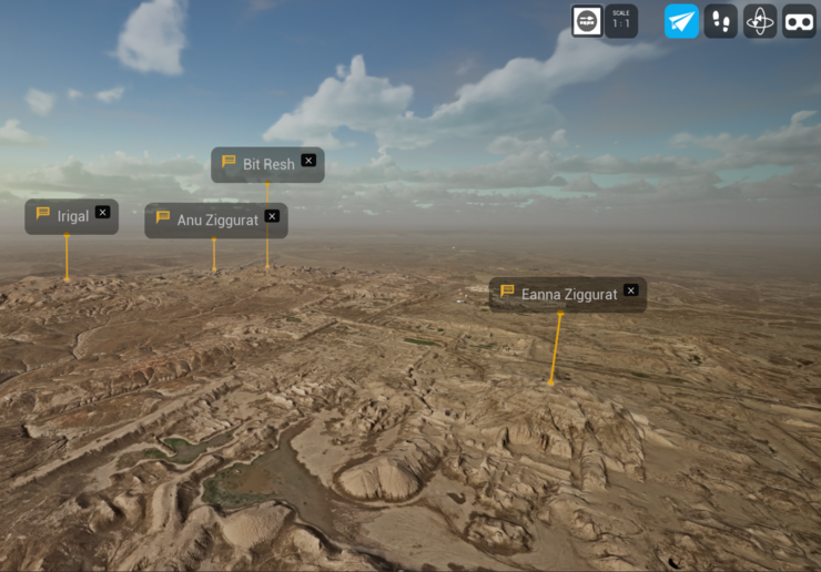
Mit Hilfe neuester Technologie aus dem Computerspielebereich war es möglich, einen digitalen Zwilling einer der bedeutendsten archäologischen Stätten der Welt zu erschaffen: Uruk.

Die von Max Haibt (Orient-Abteilung des DAI) vorgelegte Methode umfasst die effiziente dreidimensionale Erfassung von 40 Quadratkilometern mittels einem Langstrecken UAV, sowie die Entwicklung einer virtuellen Forschungsumgebung, in der das hochauflösende 3D-Modell in Echtzeit zur Verfügung steht. Die hohe Auflösung und räumliche Genauigkeit ermöglicht die wissenschaftliche Nutzung, z.B. zur genauen Bestimmung von Punkten für die Entnahme von Bohrkernen aus der Ferne oder für die Planungen von Kulturerhalt und Sitemanagement.

Der digitale Zwilling Uruks liefert wichtige Fernerkundungsdaten für bisher unerforschte Bereiche des weitläufigen Gebietes und ermöglicht neue Forschungsfragen zur Interaktion der Stadt mit ihrer Umwelt, insbesondere im Hinblick auf antike Fluss- und Kanalsysteme. Nicht zuletzt bietet Uruk-VR auch neue Möglichkeiten in der Wissensvermittlung und Bildungsarbeit. Zukünftig kann die Methode zu einer erheblichen Verbesserung geographischer und archäologischer Studien beitragen da nunmehr auch vertikale Geoinformationen, wie Bohrkerne, geophysikalische Messungen und archäologische Profile unmittelbar in das weitläufige Landschaftsmodell integriert werden können.

Die Schaffung des digitalen Zwillings wurde durch die Nutzung moderner Drohnentechnologie und neuartiger 3D-Bildverarbeitungsverfahren erreicht. Das benutzte Fluggerät hat im Vergleich zu anderen Modellen eine höhere Reichweite und verfügt über eine besonders lange Betriebsdauer. So konnten über 32.000 Luftbilder der antiken Stadt und ihrer Umgebung in nur 6 Tagen aufgenommen werden. Jedes Bild wurde mit einem präzisen Geotag versehen und mit 3D-Photogrammetrie-Software zu einem einzigen georeferenzierten Modell zusammengefügt. So entstand ein digitaler Zwilling aus einem detaillierten triangulierten Netz mit einer Milliarde Dreiecken und 1024 Texturdateien bei einer Auflösung von 8k. Durch Rendering in einer Game-Engine und die Anwendung der neuartigen Nanite und Streaming Virtual Texture Technologien kann dieser massive Datensatz in Echtzeit visualisiert werden. Dies ist möglich, weil Nanite 3D-Daten bei gleichbleibender Qualität komprimieren und effizient streamen kann.

Zukünftige Weiterentwicklungen beinhalten die Entwicklung von GIS-ähnlichen Werkzeugen, und die Integration verschiedener räumlicher Datentypen. Das hochauflösende Landschaftsmodell bildet zudem die Grundlage für die Kontextualisierung von Informationen, die in einem Jahrhundert archäologischer Forschung gesammelt wurden.

Im Sommer 2024 werden zunächst „geführte Touren“ durch das Modell angeboten. Im Anschluss wird Uruk-VR dann auch öffentlich zur selbständigen Erkundung zugänglich sein. Ein kurzes Vorstellungsvideo zu Uruk-VR ist hier verfügbar: https://www.youtube.com/watch?v=FBe9Iy-Aeck

Die Ergebnisse seiner Arbeiten wurden von Max Haibt im International Journal of Digital Earth veröffentlicht: https://www.tandfonline.com/doi/full/10.1080/17538947.2024.2324964